OUR PRESERVATION PLAN

The Hunterdon Land Trust is the only nonprofit conservation organization that works exclusively in Hunterdon County. Our land preservation efforts are focused on six project regions outlined in a comprehensive preservation plan.

A Vision for the Future

Since its founding in 1996, Hunterdon Land Trust has helped protect thousands of acres of open space and farmland in more than a dozen municipalities in Hunterdon County.

The Hunterdon Land Trust envisions a future for our county with clean drinking water and productive family farms. We see a place with beautiful landscapes, clean water, productive farms, diverse wildlife, and abundant recreational opportunities. The key to making this vision a reality is strategic land preservation. HLT has a strategic, countywide conservation plan designed to focus our efforts, make the most of our resources and work more efficiently with our partners.

The plan identifies critical areas where preservation will have the greatest impact on water quality, wildlife habitat, high-value soils, outdoor recreation, and scenic views. The Land Trust has defined six project regions based on the above criteria, with numerous target areas within each.

Project Regions

Each project region encompasses distinct natural, agricultural, and cultural landscapes that, in turn, present distinct challenges and opportunities for land preservation. The following is a summary of the regions that comprise the Land Trust’s strategic conservation plan.

Spectacular natural vistas, forested ravines, historic villages, and critical trail connectors are some of the natural and cultural resources in this area. This region boasts spectacular views of the Delaware River Valley, across to Bucks County, Pennsylvania, and State Route 29 ,the first designated scenic byway in New Jersey and also a designated Federal Scenic Byway. This stretch of the Delaware River has also received federal Scenic & Recreational River designation, with the Lower Delaware Wild and Scenic River Management Committee and the National Park Service charged with implementation of a management plan for the corridor to protect scenic values and water quality and expand and improve public recreational opportunities. Preservation of land and maintenance of adequate natural buffers along the river as well as preventing additional development, thereby reducing runoff, will help to protect bald eagles, shad and many other species. The Land Trust will focus on protecting the small, steeply wooded tributaries of the Delaware River, preserving the scenic vistas from Route 29, and protecting the rolling farmland above the river.
This region encompasses the watersheds that flow into the Delaware River. Though much of the area is agricultural, the stream corridors and adjoining wetlands provide critical wildlife habitat, and there are numerous opportunities for hiking and other forms of outdoor recreation. Water protection is critical here because the Delaware River and D&R Canal serve millions of water users in central New Jersey. The Land Trust will build on its previous successes in this region by focusing on parcels that adjoin to already preserved lands, particularly in the Nishisakawick, Lockatong and Alexauken watersheds.
Steep forested slopes and small farms fringe the Musconetcong River in Bethlehem, Holland and Lebanon Townships. A federally designated Wild and Scenic River, the “Musky” is a major tributary of the Delaware River and is one of the state’s finest trout fishing streams. The river corridor encompasses critical habitat for state-listed threatened, endangered or rare species. It lies entirely within the New Jersey Highlands Region, designated a “landscape of national importance” by the U.S. Forest Service, and is situated within the Atlantic Flyway, one of four major migratory bird routes in North America.
This Project Region is in Readington and Tewksbury Townships with a small portion in Lebanon Township. As the second main stem of the Raritan River, the North Branch and its tributaries, including the Rockaway and Lamington Rivers, are vital sources of drinking water. While this project area is relatively new to the Hunterdon Land Trust, opportunities exist to partner with organizations that are already active here.
This region extends south from the Highlands near Califon to the agricultural grasslands of the Amwell Valley. Protecting water sources is essential here. The South Branch and its associated reservoirs – Round Valley and Spruce Run – provide high-quality drinking water to more than 1 million New Jersey residents. Our focus includes key watershed properties, wildlife habitat, links between preserved parcels, and projects that protect the community character of the region’s small towns and provide recreational opportunities.

Sourland Mountain spans three counties and five municipalities and is the largest, most intact forest in central New Jersey. As such, it is a vitally important area for state threatened and endangered wildlife and migrating birds. The Hunterdon County portion of the Sourlands is in East Amwell and West Amwell Townships. This is a new region for the Hunterdon Land Trust, and we will seek partnerships with conservation organizations and government agencies that are already working in the area.

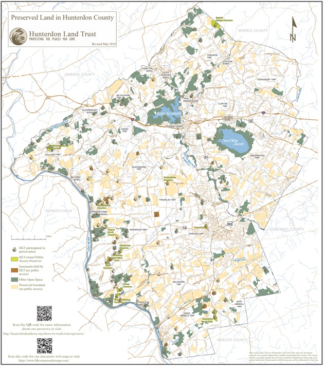
Map of preserved land in Hunterdon County

Download Preservation Map
Download Preservation Plan